
This street, created in 1919 by Ordinance 39638, is named for W Marginal Way SW. It begins there and goes just under 800 feet northwest to a dead end underneath the West Seattle Bridge. The Duwamish Trail continues on from there to the West Seattle Bridge Trail, while the 18th Avenue SW stairway heads south up the hill to SW Charlestown Street in Pigeon Point.
W Pleasant Place
This street was created in 1890 as part of the Queen Anne 3rd Addition to the City of Seattle, platted by Frank Morrell Jordan (1863–1931) of F.M. Jordan & Co. According to Clarence Bagley’s History of Seattle from the Earliest Settlement to the Present Time, he had been “connected with Seattle throughout the entire period of its development since the fire of 1889 and has been in hearty sympathy with the movement for the building of the city upon broader and more beautiful municipal lines.”
As the street is less than 150 feet south of Mount Pleasant Cemetery, I assume that is the origin of its name.
W Pleasant Place exists in two short segments not much longer than 150 feet each. Both head east: one from 7th Avenue W and the other from 6th Avenue W, neither making it a whole block.
Birch Avenue N
This street was created in 1890 as part of Hunter’s Lake Union Addition to the City of Seattle by Colonel Morton C. Hunter (1825–1896), Civil War veteran and congressman from Indiana. (His son, Frank, was an insurance and real estate man in Seattle, and it was he who requested the recording of the plat.) Absent any evidence to the contrary, I assume it was named for the tree, though it is the only such street in the plat.
Birch Avenue N begins at Halladay Street just east of Aurora Avenue N and south of Canlis, and goes 300 feet southeast to a dead end.
SW City View Street
This street was created in 1905 as part of the Steel Works Addition to West Seattle by Albert C. Phillips. Originally Cityview Street, it formed a trio with Grandview Street and Bayview Street, which are today SW Hinds Street and SW Spokane Street, and was named for its view of Seattle, to the northwest across Elliott Bay.
SW City View Street begins at 35th Avenue SW as a driveway and foot path which becomes a paved street just before 34th Avenue SW and extends just beyond, about 325 feet in all. The right-of-way continues through a greenbelt, and the road picks up at again at SW Admiral Way, where it goes 500 feet east to end at 30th Avenue SW.
Red Avenue E
This short street in the Eastlake neighborhood was created in 1887 as part of Greene’s Addition to the City of Seattle, named for and filed by, among others, Roger Sherman Greene (1840–1930) and his wife, Grace Wooster Greene (1833–1917). Instead of naming a street directly after themselves, they dropped an e and named the north–south streets in the plat for (most of) the colors of the rainbow: Red, Orange, Yellow, Green, Indigo, and Violet. Only Red has survived to this day.
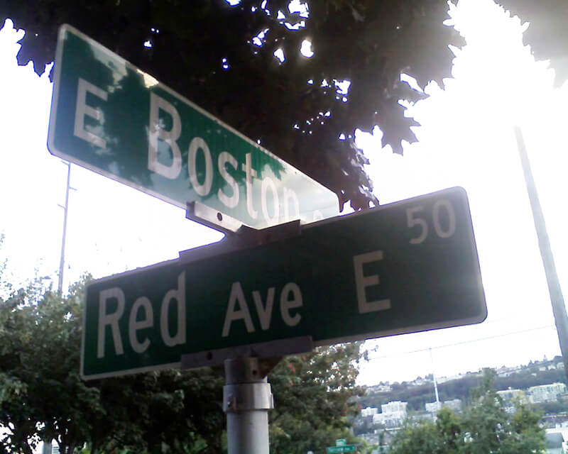
Red Avenue E begins at E Boston Street and goes around 150 feet north to a dead end.

Sign at corner of E Boston Street and Red Avenue E, September 1, 2010. Photograph by Benjamin Lukoff. Copyright © 2010 Benjamin Lukoff. All rights reserved. SW Maryland Place
This short West Seattle street was created along with Elm Place SW as part of the 1888 First Plat of West Seattle by the West Seattle Land and Improvement Company. Originally Courtland Street, it became joined to Maryland Street when the latter was created as part of the 1895 Seattle Tide Lands plat. When West Seattle was annexed to Seattle in 1907, both were renamed Maryland Place.
(The tideland streets in West Seattle were, with a few exceptions, named after states: Illinois, [New] Hampshire, Arkansas, [New] Jersey, Rhode Island, [New] Mexico, Maryland, Louisiana, Georgia, [North and South] Carolina, Florida, Mississippi, Oregon, [North and South] Dakota, and Idaho. Of the ones confined to West Seattle, only Maryland remains [Florida, Oregon, Dakota, and Idaho also, or only, appear east of the West Duwamish Waterway].)
Today, SW Maryland Place begins at Elm Place SW and goes around 130 feet northeast to Harbor Avenue SW.

The Stone Cottage, corner of SW Maryland Place and Harbor Avenue SW, December 31, 2020. The campaign to save the building succeeded, and it was moved into storage on August 18, 2021. Photograph by Flickr user Mark Ahlness, licensed under Creative Commons Attribution-NonCommercial-NoDerivs 2.0 Generic Elm Place SW
This short West Seattle street was created as part of the 1888 First Plat of West Seattle by the West Seattle Land and Improvement Company. Originally Elm Street, it had companions in Oak, Maple, and Laurel Streets, none of which survive.
Elm Place SW begins at SW California Place and goes 300 feet southeast to SW Maryland Place, paralleling Harbor Avenue SW just over 100 feet to its northeast.
Keen Way N
This street originates in the 1924 plat of Winona Park, an Addition to the City of Seattle, filed by George Emerson Morford (1890–1946) and his wife, Gertrude Alice Keen Morford (1892–1954). According to Florence Helliesen of the Queen Anne Historical Society, George was president of the F.W. Keen Company, a real estate firm owned by his father-in-law, Frederick Walter Keen (1855–1929). The Seattle Civil Rights & Labor History Project writes:
Two real estate firms, F.W. Keen Company and J.L. Grandey, Inc., organized most of the racial restrictive covenants for Queen Anne from 1928 to 1931… specifying that “No person or persons of Asiatic, African or Negro blood, lineage, or extraction shall be permitted to occupy a portion of said property, or any building thereon; except domestic servants may actually and in good faith be employed by white occupants of such premises.”
In addition to being president of F.W. Keen, George Morford was vice president of J.L. Grandey.
Which Keen was honored by Keen Way N — Gertrude Alice Keen Morford, Frederick Walter Keen, or the F.W. Keen Company — isn’t clear; if it was for George Morford’s wife, that would put Keen Way in the same category as Perkins Lane W and Thorndyke Avenue W.
Keen Way N begins at Aurora Avenue N between W Green Lake Drive N and Winona Avenue N and goes ⅕ of a mile northeast to N 76th Street.

Frederick Walter Keen, from his Seattle Times obituary, August 14, 1929. I was unable to locate a photograph of his daughter, Gertrude. Whitney Place NW
This street, originally W 93rd Street in the 1907 plat of Loyal Heights, filed by Edward B. Cox, Harry Whitney Treat (1865–1922), and Treat’s wife, Olive Marion Graef Treat (1869–1945), appears to honor Harry’s middle name, which was also part of his mother’s name and was his grandmother’s maiden name. It begins at View Avenue NW and 32nd Avenue NW and goes just under 300 feet northeast to NW 95th Street.

Harry Whitney Treat riding a horse, by John Ross “Dok” Hager, circa 1910 Densmore Avenue N
This street is named for Milton Densmore (1839–1908), a Civil War veteran from Chelsea, Vermont, who, according to Clarence Bagley’s History of Seattle from the Earliest Settlement to the Present Time, fought in the Battles of Fairfax Court House, Gettysburg, and Rappahannock Station. He returned to Vermont after the war, then moved to Beloit, Wisconsin, in 1867. Densmore came to Seattle in 1871. Sophie Frye Bass relates in Pig-tail Days in Old Seattle that he started out as “one of the captains of the Linna C. Gray, the stocky barge that carried coal from shore to shore in Lake Union.” In 1875, he opened a grocery, which closed in 1887. Bagley adds that
With various interests of Seattle he was closely associated. He laid the first steel rail for the street car system of Seattle, wooden rails having been used previous to that time. He served for two terms as a member of the city council and exercised his official prerogatives in support of various plans and measures for the general good. He served for seven years as a member of the school board and the cause of education found in him a stalwart champion. Densmore Avenue of Seattle was named in his honor and Seattle in many ways acknowledges her indebtedness to him. He did much toward improving property, built residences and otherwise aided in enhancing the attractiveness of the city and at all times was public spirited and active.

Milton Densmore, from the November 10, 1907, issue of the Seattle Post-Intelligencer. The story was about his reunion with his brother, Jason Densmore, whom he hadn’t seen in over four decades, since the Civil War ended (Jason was likewise a Union soldier from Vermont). Densmore Avenue N begins at N Northlake Way, just north of Gas Works Park. It then goes ¾ of a mile north to the Wallingford Playfield at N 42nd Street. Resuming a block north, it goes a further ⅖ of a mile to N 50th Street. It picks up again at the north end of Green Lake, where Green Lake Drive N splits into W Green Lake Drive N and E Green Lake Drive N, and goes ⅗ of a mile to Cascadia Elementary School at N 90th Street. Densmore resumes at N 92nd Street and goes another ⅗ of a mile, past Licton Springs Park, to Mineral Springs Park at N 105th Street. It picks up again just north of N Northgate Way for a couple blocks before being stopped by Evergreen–Washelli Cemetery and UW Medical Center – Northwest. After a short segment north of the hospital, it then forms part of the ring arterial around Haller Lake, going ⅓ of a mile from N 122nd Street to N 128th Street, and finishes up with a ½-mile-long segment from Ingraham High School at N 135th Street to the city limits at N 145th Street. (As with many other North Seattle avenues, the name continues on into Shoreline; its northernmost appearance is between N 202nd Place and N 203rd Place, just south of the King–Snohomish county line at N 205th Street.)
Wickstrom Place SW
This street is named for Peter Wickstrom (1837–1915), who immigrated to the United States from Sweden in the late 1860s. According to Thomas Ostenson Stine’s Scandinavians on the Pacific, Puget Sound, he lived in St. Paul, Minnesota, and Portland, Oregon, before coming to Seattle. His obituary, which ran in The Seattle Times on January 15, 1915, the day after his death, reads in part:
Peter Wickstrom, well-known pioneer of Seattle and an extensive realty holder, died unexpectedly yesterday afternoon after leaving the dinner table at his residence near Alki Point.… The deceased made his home at “The Old Homestead,” a tract of land not far from Alki Point.… Wickstrom came to this city in 1873 and conducted a hotel prior to the fire of 1889. Subsequent to that time he had not engaged actively in business.

Peter Wickstrom, from his Seattle Times obituary Wickstrom Place SW begins at 54th Place SW just south of Alki Avenue SW and goes around 500 feet south to a dead end.

The Peter Wickstrom tract in Baist’s 1912 atlas of Seattle The Peter Wickstrom tract in Kroll’s 1920 atlas of Seattle
Peter Wickstrom’s 7.18-acre tract before and after his death. Boyd Place SW
This West Seattle street was created in 1920 as part of Sarah M. Boyd’s First Addition to the City of Seattle. I believe Sarah Maria Loudenback Boyd (1853–1932) to be the Sarah M. Boyd in question here.
Boyd Place SW begins at 59th Avenue SW and SW Charlestown Street and goes around 425 feet southeast to Chilberg Place SW and Aikins Avenue SW.
Chilberg Avenue SW
This West Seattle street was created in 1889 as part of Chilberg’s Addition to West Seattle, filed by Swedish immigrants Nelson Chilberg (1840–1928) and his wife, Matilda Charlotta Schanstrom Chilberg (1846–1927). The Chilbergs started out as farmers and grocers before developing real estate interests.

Matilda Chilberg 
Nelson Chilberg
Matilda and Nelson Chilberg. Her photo is from the July 17, 1927, issue of the The Seattle Times; his is from the December 15, 1928, issue of the Seattle Post-Intelligencer. Chilberg Avenue SW begins at 59th Avenue SW and SW Carroll Street and goes ⅕ of a mile southeast to SW Genessee Street just east of Beach Drive SW at the Emma Schmitz Memorial Overlook and Me-Kwa-Mooks Park.
Clarmar Place SW
This West Seattle street is really more of a footpath, being narrow, unpaved, and closed to motor vehicles. The public right-of-way runs about 450 feet northwest from Bonair Drive SW as it descends through the Duwamish Head Greenbelt from Sunset Avenue SW to Alki Avenue SW, and the path continues for some 1,150 feet more through property owned by the parks department.
Clarmar Place SW was created in 1941 as part of the plat of Clarmar Crags, which name appears to be a combination of Clara Coumbe (died 1975?), landowner, and mar, for its location above Elliott Bay and Puget Sound.
S Spokane Street
I haven’t posted in a couple of weeks because I’ve been in Spokane, visiting my wife’s family for the holidays and attending the memorial service of my sister-in-law, may her memory be for a blessing. Since there is no Emily Street in Seattle, why not return, then, with a post on Spokane Street?

S Spokane Street looking west from 1st Avenue South, July 5, 2013. Photograph by Flickr user Curtis Cronn, licensed under Creative Commons Attribution-NonCommercial-NoDerivs 2.0 Generic. The barcodes on the support columns for the Spokane Street Viaduct was, in the words of the artwork’s creators, Claudia Reisenberger and Franka Diehnelt, intended “to ‘label’ the many layers that constitute SoDo’s history”; the word visible at upper left, ‘slóóweehL’, is a Lushootseed-language word that, according to Coll Thrush, author of Native Seattle: Histories from the Crossing-Over Place, “refers to channels, or ‘canoe-passes’, in the grassy marsh through which canoes can be pushed to effect a shortcut,” and was a Duwamish place name referring to what is now approximately 4th Avenue S and S Spokane Street. (Incidentally, this is the same word rendered as sluʔwiɫ in the IPA-based Lushootseed alphabet, which was also used as a name for what is now University Village, and is now the official name of a street on the University of Washington campus.) Spokane Street appears to have been created in 1895 as part of the Seattle Tide Lands plat. Streets in this plat that were not extensions of already existing ones, such as Commercial Street, were named after letters of the alphabet, American cities, American states, prominent local politicians, and places in Washington. The letters of the alphabet and the American cities appear in alphabetical order, but the states appear neither in alphabetical nor geographic order, and the places in Washington do not appear to be in any order whatsoever (except that a number beginning with Q are physically clustered together). They are as follows, listed alphabetically:
* Still exists
(I leave out West Point Avenue [which still exists, but only as a paper street] and Seattle Boulevard [now Airport Way S and Diagonal Avenue S] because the former was named for its proximity to West Point and the latter, it seems, for its prominence.)
It isn’t a list entirely composed of cities, islands, peninsulas, lakes, or rivers… the only things I notice are ⅔ of them are in Western Washington, with Chelan, Klickitat, and Wenatchee being in Central Washington and Spokane being in Eastern Washington; plus half the Western Washington locations (those beginning with Q) are on the Olympic Peninsula. It seems what is today Spokane Street could just as easily have been something else, and what is today such a prominent street wasn’t purposefully named after what was then the state’s third largest city (today, it ranks second).

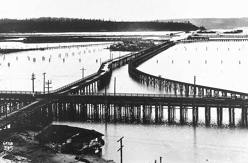
Trestles over the Elliott Bay tideflats, 1905. Photograph by Ira Webster and Nelson Stevens. According to the Wikimedia Commons entry for a similar photograph, the trestle in the foreground, running right to left (north to south), is today’s Airport Way S; the parallel trestle in the distance is 4th Avenue S; and running perpendicular from lower left to upper right (east to west, toward West Seattle) is S Spokane Street. The Seattle Box Company plant is visible at 4th and Spokane. 
A modern view of the Industrial District, Harbor Island, and West Seattle from above Beacon Hill, August 15, 2010. Photograph by Flickr user J Brew, licensed under Creative Commons Attribution-ShareAlike 2.0 Generic. The freeway in the foreground, running right to left (north to south), is Interstate 5. Airport Way S is visible just west of the freeway. The Spokane Street Viaduct and West Seattle Bridge can be seen at left heading from Beacon Hill to West Seattle. 4th Avenue S is still a major arterial, though it isn’t nearly as prominent in this photograph as the one taken 105 years earlier. Today, SW Spokane Street begins in West Seattle at Beach Drive SW, ½ a mile southeast of Alki Point, then goes nearly ½ a mile east to Schmitz Park, the block between 61st Avenue SW and 60th Avenue SW being a stairway. It resumes on the other side of the park at 51st Avenue SW and goes another ½ mile to 42nd Avenue SW. After a few interrupted segments between 35th Avenue SW and 30th Avenue SW, including another stairway, it begins again in earnest at Harbor Avenue SW and SW Admiral Way. From here it goes a full 2¼ miles east to Airport Way S, crossing the Duwamish Waterway and Harbor Island on the Spokane Street Bridge, and for this entire length runs either underneath or in the shadow of the West Seattle Bridge or the Spokane Street Viaduct, the latter of which leads to S Columbian Way on Beacon Hill.
After a short segment between Hahn Place S and 13th Avenue S, S Spokane Street begins again at 14th Avenue S and S Columbian Way and goes ⅔ of a mile east to 24th Avenue S. With the exception of an even shorter segment hanging off 25th Avenue S north of the Cheasty Boulevard greenspace, it next appears in Mount Baker, where it runs for two blocks between 33rd Avenue S and 35th Avenue S (part of this being stairway); then two more blocks between 36th Avenue S and York Road S (featuring another stairway); and two final blocks between 37th Avenue S and Bella Vista Avenue S.

Portion of 1895 plat of Seattle Tide Lands showing Spokane Avenue, now Spokane Street. The visible portion of Seattle Boulevard is now Diagonal Avenue S, and Whatcom Avenue is E Marginal Way S. Portions of Chelan Avenue, Klickitat Avenue, and Duwamish Avenue still exist, as do Oregon Street, Dakota Street, Idaho Street, Colorado Avenue, and Utah Avenue. Twin Maple Lane NE
This private cul-de-sac at the end of 24th Avenue NE south of NE 60th Street appears, according to an article in the June 19, 1927, edition of the Seattle Post-Intelligencer, to have been established that very year. According to James Bush writing for the Seattle Sun, Ravenna Park (or perhaps a portion thereof) was once known as Twin Maple Park, and
[William Wirt] Beck is officially remembered by two of the smallest civic gestures ever performed. In keeping with the early practice of giving names to small bits of park property, the concrete-covered triangle of land at the intersection of 15th Avenue Northeast and Cowen Place was dubbed Beck Place. And, his beloved Twin Maples Park is memorialized by Twin Maples Lane Northeast, a half-block street where 24th Avenue Northeast meets the park border.
Note that the typos are in the Sun article, not this post — the sign quite clearly says Maple, not Maples.
Park Road NE
Like its twin, NE Park Road, this street originates in the 1923 Park Home Addition developed by William Wirt Beck. They are the home of Candy Cane Lane, which has been a local Christmas attraction since 1948.
Park Road NE begins as an extension of 21st Avenue NE at NE Ravenna Boulevard and goes around 100 feet north to NE Park Road at Park Home Circle.

Candy Cane Lane at night, December 2009. Photograph by Flickr user Tony J. Case, licensed under Creative Commons Attribution-NonCommercial-ShareAlike 2.0 Generic NE Park Road
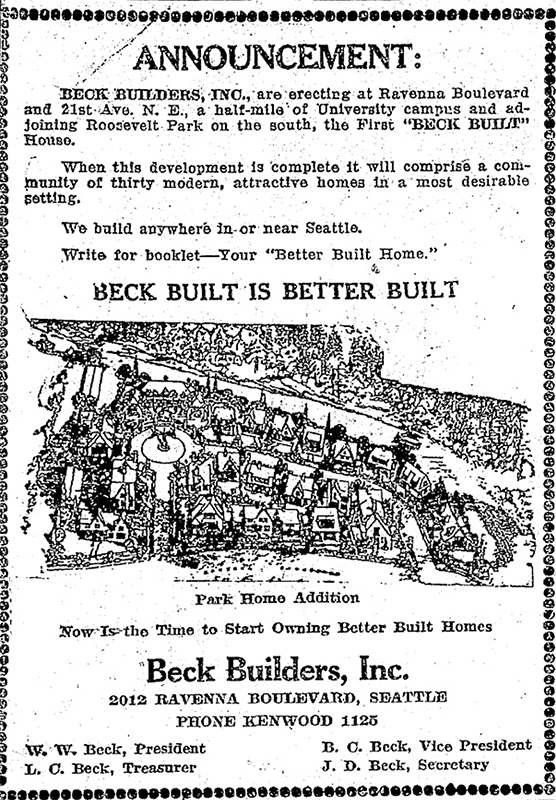
This street and its twin, Park Road NE, date to 1923, when William Wirt Beck developed the Park Home Addition between NE Ravenna Boulevard and Ravenna Park. They are best known for being the location of Candy Cane Lane, which has been a local Christmas attraction since the late 1940s. (The Park Road house of one Eugene Shostrom frequently appeared on The Seattle Times’ Christmas Tree Trail list before then, but it wasn’t until 1948 that the neighborhood as a whole participated — and won the award for best community display. [I wonder where that loving cup is today…])

Season’s Greetings from Candy Cane Lane sign, December 2013. Photograph by Flickr user Frank Fujimoto, licensed under Creative Commons Attribution-NonCommercial-NoDerivs 2.0 Generic NE Park Road begins at NE Ravenna Boulevard just west of Ravenna Avenue NE and goes around 350 feet first north, then west, to Park Road NE at Park Home Circle.

Park Home Addition Ad, The Seattle Times, April 30, 1923 E Park Drive E
This street, like W Park Drive E — its twin on the other side of Montlake Boulevard E — was created in 1908 as part of Montlake Park, an Addition to the City of Seattle, and was named after what is now East Montlake Park.
It begins at the east end of E Hamlin Street by the old location of the Museum of History and Industry (currently a staging area for the Montlake Project portion of the rebuilding of Washington State Route 520) and goes 300 feet north to E Shelby Street.
East Montlake Park totem pole, carved by John Wallace, July 2009. The pathway is the Lake Washington Ship Canal Waterside trail, which connects East Montlake Park to West Montlake Park along the Montlake Cut. Photograph by Flickr user camknows, licensed under Creative Commons Attribution-NonCommercial-ShareAlike 2.0 Generic W Park Drive E
This street was created in 1908 as part of Montlake Park, an Addition to the City of Seattle, and was named after what is now West Montlake Park. It has a twin, E Park Drive E, on the other side of Montlake Boulevard E.
W Park Drive E begins at the west end of E Hamlin Street by the Seattle Yacht Club and goes 300 feet north to E Shelby Street.
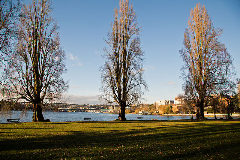
West Montlake Park, January 2013. The body of water is Portage Bay (Lake Union); South Campus of the University of Washington is at right, across the Montlake Cut, and the University Bridge and Ship Canal Bridge are visible in the distance. Photograph by Orange Suede Sofa, Wikimedia Commons, licensed under Creative Commons Attribution-ShareAlike 3.0 S Delappe Place
This street originates in the 1908 plat of De Lappe’s Addition to the City of Seattle, filed by Emanuel Marcellus DeLappe (1854–1928) and his wife, Catherine E. McGeehan DeLappe (1856–1934). According to the North Rainier Valley Context Statement, “[he] was a saddler and harnessmaker who came to Seattle in about 1890”; in the September 1900 issue of The Leather Workers Journal, it was reported that he had recently been elected president of Branch № 66 of the United Brotherhood of Leatherworkers on Horse Goods.
S Delappe Place begins at the end of 27th Avenue S, south of S Horton Street, and goes around 175 feet west to a dead end at the Cheasty Boulevard greenspace.
Anthony Place S
This street originates in the 1907 plat of Cascade View Addition to the City of Seattle, King County, Washington. Originally Della Street, it appears to have been renamed for William Gordon Anthony and his wife, C. Nana Anthony, who filed the plat. William, who died June 8, 1925, at the age of 64, had been working in insurance and real estate since 1910, according to his obituary in the June 10 issue of The Seattle Times. In it, his wife’s name is given as Canana, not C. Nana, as the plat has it. (Curiously, her own death certificate [she died November 6 of the same year at the age of 57] gives her name as C. Nanny!)
Anthony Place S begins at 27th Avenue S just south of S Walden Street and S Della Street and goes less than 100 feet southwest before turning into a private driveway, which turns into an alley, which turns into another private driveway that connects to Cheasty Boulevard S. The undeveloped right-of-way continues southwest for another ⅐ of a mile.
Short Place S
This, well, short street in the Leschi neighborhood originates in Wood’s Supplemental Plat of Blocks 16 and 17, Burke’s 2nd Addition to Seattle, filed in 1887 by, among others, William D. Wood (1858−1917) and his wife, Emma Wallingford Wood (1859−1949). William, who was later mayor of Seattle from 1896 to 1897, was one of the principal developers of the Green Lake neighborhood; Emma was the daughter of John Noble Wallingford (1833–1913), after whom the Wallingford neighborhood and Wallingford Avenue N are named.
Short Place S begins at S Jackson Street and goes about 425 feet south to S King Street.
Sunset Avenue SW
I enjoy writing posts on streets like W Commodore Way (I believe I am the first to have accurately identified its namesake), Division Avenue NW (I show that, even though it doesn’t divide anything from anything else today, it once served as Ballard’s eastern city limit for a few blocks), Loyal Avenue NW (I discover that it’s named not for the concept of loyalty, but for a baby girl whose first name was Loyal), and sluʔwiɫ (the University of Washington’s new Lushootseed-language name for Whitman Court). But sometimes I just like knocking something out quickly (I’m looking at you, W View Place and View Avenue NW). Sunset Avenue SW is another one of those. It originated in the 1888 First Plat of West Seattle by the West Seattle Land and Improvement Company, and the name simply refers to the street’s western view of Puget Sound; Vashon, Blake, and Bainbridge Islands; the Kitsap Peninsula; and the Olympic Mountains.
Sunset Avenue SW begins as a stairway at California Avenue SW, just across the street from Hamilton Viewpoint Park. Once the roadway begins up the hill, it goes ⅘ of a mile southwest to a dead end at the College Street Ravine southwest of 50th Avenue SW.
Victory Lane NE
This street, which was originally named Lake View Lane in the 1920 plat of Victory Heights, appears to have received its current name no later than August 1943, when it first appears in the Seattle Post-Intelligencer as part of the obituary of Dr. Lewis R. Dawson, “dean of Seattle physicians and surgeons.” (Victory Heights was itself named for Victory Way, known today as Lake City Way NE within Seattle city limits and as Bothell Way NE in Lake Forest Park, Kenmore, and Bothell. The road was given this name in the wake of the Allied victory in World War I.)
My first thought was that Lake View Lane had been renamed Victory Lane to preserve the Victory Way name after the highway became Bothell Way, but it turns out that happened a number of years later, so I am unsure as to the reason for this name change.
Mayes Court S
This street was created in 1924 as part of Mayes’ Addition to the City of Seattle, filed by Wilbur Mayes (1871–1949); his wife, May H. Stutz Mayes (1870–1948); and George Moore. According to the reports of their deaths in The Seattle Times, on October 5, 1949, and October 14, 1948, respectively, the Mayeses were married in 1896 and lived in the Philippines, where Wilbur was a lumberman, from 1905 to 1912. They moved from the Philippines to Seattle, where he became an accountant. He apparently became a house repairman after retirement, and died after falling 15 feet from a University District neighbor’s roof.
Interestingly, it appears on the plat map as Mayes’ Court, with the apostrophe, but its official name lacks the punctuation, as do, I believe, all Seattle streets. (We have no streets named O’Brien, O’Reilly, O’Sullivan, or the like; I suppose an exception would have been made in such cases.)
Mayes Court S begins at S Carver Street and goes about 350 feet northwest to a cul-de-sac.
NE Brockman Place
This street appears to have been named for Charles Carl Brockman (1869–1954), proprietor of the unrecorded plat of Brockman’s Tracts. According to the obituary of his son, Charles Clark Brockman (1915–2010), the elder Brockman was “a Seattle pioneer who owned a grocery store [and] various real estate interests in the Denny Regrade and Lake City area.”
NE Brockman Place begins at 19th Avenue NE just north of NE 127th Street and goes ¼ mile northwest to just west of 14th Place NE.
NW Culbertson Drive
This street was created in 1955 as part of the plat of Llandover-by-the-Sound, filed by (among others) Ralph Glossbrerer Culbertson (1886–1975), a developer, and his wife, Jane R. Effie Redding Culbertson (1884–1976). R.G., as he was known, appears to have earlier been in the storage and moving business, and had “an extensive acquaintance with eight [Canadian] provinces.”
NW Culbertson Drive begins at Hilltop Lane NW and goes ⅓ of a mile west to a dead end overlooking Puget Sound.
Sherman Road NW
This street was created in 1958 as part of Northshire, an Addition to the City of Seattle, filed by Sherman O. Jensen (1919–2002) and his wife, Dorothy (1920–2008), along with Jeannette D. Jackson and her husband, Paul J. Jackson.
Sherman Road NW begins at NW 137th Street and goes about 625 feet to the south, where it turns into Northshire Road NW.
Frazier Place NW
This street, originally Sound View Place, was created in 1920 as part of Frazier’s Addition to King County, Washington, filed by Raymond Robert Frazier (1873–1955) and his wife, Augusta Wood Frazier (1874–1969). Raymond was president of Washington Mutual from 1915 to 1933 and its chairman from 1933 to 1941.
Frazier Place NW begins at NW 132nd Street and goes just over 300 feet north to NW 134th Street.

Raymond R. Frazier, from The Town Crier, September 26, 1931


.jpg)
.jpg)