“Look! They’ve finally signed the W Galer Street Flyover!” I thought to myself the other day as I drove onto the Magnolia Bridge onramp from 15th Avenue W. “I wonder why they took so long?” (It was built in 2002.)
It made sense for the private road — originally Amgen Court W after the campus’s previous corporate occupants — to change its name… but why to Expedia Group?
Yes, Expedia’s official name is Expedia Group — it’s the parent company not only of the eponymous online travel agency but of many other brands, including Hotels.com, Orbitz, Travelocity, Hotwire, and CheapTickets — but still. Wouldn’t Expedia Way W sound and look better? Adding the “group” makes the name sound much more corporate to my ear.
As of this writing, Seattle’s newest street name is E Barbara Bailey Way — formerly the block of E Denny Way between Broadway and 10th Avenue E.
Barbara Bailey, who died on September 1, 2018, was best known for Bailey/Coy Books, which she founded on Broadway in 1982. As Seattle Mayor Jenny Durkan wrote,
Barbara’s commitment to action made her an early pioneer for LGBTQ+ rights. Her bookstores – B. Bailey Books and Bailey/Coy Books – were nationally beloved independent book stores that regularly brought communities together and hosted renowned authors. They were also safe and welcoming spaces for the LGBTQ+ community, particularly for those just coming out and during the height of anti-LGBTQ+ actions.
Barbara Bailey Way is one of a number of “festival streets” in the city of Seattle.
Before white settlers came to to dzidzəlalič in 1852, before they came to sčəgʷaliču in 1832, even before they first sighted the shores of x̌ʷəlč in 1792, the dxʷdəwʔabš were here, living at sluʔwił and šilšul, babaqʷəb and t’uʔəlalʔtxʷ, and paq’ác’ałčuʔ and səxʷt’ičib, by the lakes called c’alq’ʷadiʔ and sisałtəb and dxʷƛ’əš and xáx̌əʔčuʔ, and most of all xačuʔ — the lake — the smaller ones being fed by springs like liq’təd where the waters run red, the lake being fed by the river whose mouth was at ƛ’ax̌ʷadis, but one by one their names were replaced by the settlers, who though they named the city for siʔał and the river for the dxʷdəwʔabš nevertheless named places Pioneer Square for themselves, or Fremont for where they came from, or Brooklyn for that which they aspired to be, and while šilšul became Shilshole and liq’təd became Licton, other dxʷləšúcid names were left unwritten and hardly spoken for decades but still remembered — so let Carkeek remain Carkeek, but know that it was once and is still kʷaatəb, as Montlake is still stəx̌ʷugʷił, the Locks, which lowered xačuʔ and xáx̌əʔčuʔ, still xʷiwálqʷ, and University Village still sluʔwił village, and celebrate that wǝɫǝbʔaltxʷ now sits where Whitman and Stevens meet.
I selected most, though not all, of the names by using the Burke Museum’s Waterlines Project map. They appear below, along with their translations and the current, settler-given names.
dzidzəlalič — Little Crossing-Over Place — Pioneer Square
sčəgʷaliču — Extensive Sand Banks Over Which the Water Is Shallow/Big Tide/Long Run-Out — Sequalitchew/Fort Nisqually/DuPont
x̌ʷəlč — Salt Water — Puget Sound
dxʷdəwʔabš — People of the Inside (Elliott Bay) — Duwamish
sluʔwił — Little Canoe Channel — University Village
šilšul — Tucked Away Inside — Salmon Bay (Shilshole is one of two unchanged Native names within Seattle city limits)
babaqʷəb — Little Prairie — Belltown
t’uʔəlalʔtxʷ — Herring’s House — West Seattle Industrial District
paq’ác’ałčuʔ — Brush Spread on the Water — West Point
səxʷt’ičib — Place Where One Wades — Lakeridge
c’alq’ʷadiʔ — Blackcaps on the Sides — Bitter Lake
sisałtəb — Calmed Down a Little — Haller Lake
dxʷƛ’əš — translation unknown — Green Lake
xáx̌əʔčuʔ — Small Lake — Lake Union
xačuʔ — Lake — Lake Washington
liq’təd — Red Paint — Licton Springs, the other unchanged Native name within Seattle city limits
ƛ’ax̌ʷadis — The Growing Place — Squawk (Squak) Slough, mouth of the Sammamish River at Kenmore
What better way to start things off than with SW Seattle Street?
SW Seattle Street is a minor residential street in West Seattle that runs about ³/₁₀ of a mile from 42nd Avenue SW in the east to Sunset Avenue SW in the west.
It might seem strange that such a short street would be chosen to bear the city’s name — it was the only one to do so until 2010, when the first two blocks of Airport Way S were renamed Seattle Boulevard S — but this has more to do with unimaginative naming than with civic pride.
On August 4, 1869, Ike M. Hall — the executor of the estate of Norman B. Judkins — filed the Judkin’s (sic) Addition to the Town of Seattle, located just southwest of where the interchange between I-5 and I-90 is today. From north to south, the east–west streets are named Norman, B, Judkins, Addition, Town, and Seattle.
Portions of the original Seattle Street were vacated over the years (for example, in 1900, 1957, and 2000), and the construction of I-5 took care of the rest. However, when the city annexed West Seattle in 1907 it changed the name of Maple Street to W Seattle Street as part of rationalizing the street grid… and so the name lives on.
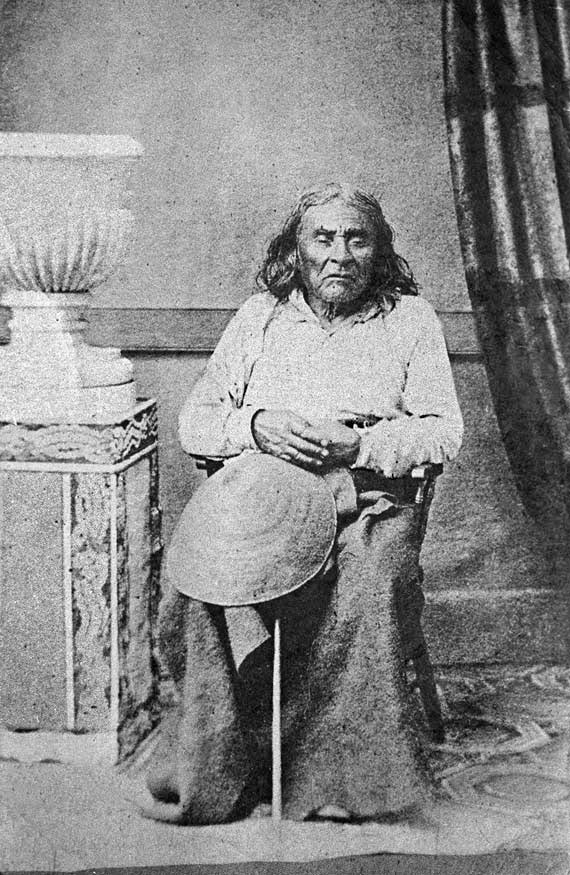
(The city itself, of course, was named after Si’ahl [siʔaɫ], better known in English as Chief Seattle of the Duwamish and Suquamish Tribes.)
The only known photograph of Chief Seattle (1786?–1866), taken by E.M. Sammis in 1864
So, why SW Seattle Street instead of Seattle Street SW?
In Seattle, east–west streets have the directional come first, and north–south avenues have it come last. The Wikipedia article “Street layout of Seattle,” which I helped write, has a more comprehensive description of Seattle’s addressing system, including the answer to this question:
Why was it W Seattle Street in 1907 but SW Seattle Street now?
In 1961, city ordinance 89910 “established a standard system of street name designations” so that in almost all cases streets within a given zone would carry the same directional. West Seattle avenues already carried the SW designation.