California Avenue SW — a major West Seattle arterial connecting the Admiral, Alaska, and Morgan Junctions (three commercial hubs named after long-gone streetcar line intersections) — runs 4½ miles from California Lane SW in the north, past which it turns into California Way SW on its way down the hill to the waterfront, to SW Sullivan Street in the south. Beyond there it exists as a few short segments, then briefly as part of the SW Brace Point Drive–SW Barton Street arterial, and lastly as a nearly mile-long residential street that ends at Marine View Drive SW.
This street lies mostly in Columbia City, where its name originated, and Seward Park, with a few blocks in Beacon Hill and even fewer in West Seattle. It almost reaches Puget Sound at Beach Drive SW, and does reach Andrews Bay of Lake Washington at Lake Washington Boulevard S.
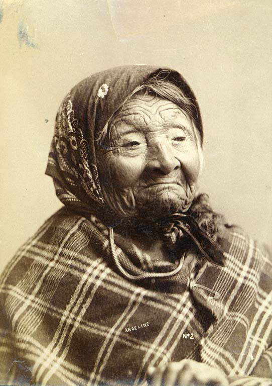
Princess Angeline was born Kikisoblu, the daughter of Si’ahl [siʔaɫ], better known in English as Chief Seattle of the Duwamish and Suquamish Tribes. Her date of birth is unknown; Wikipedia gives it as ca. 1820, whereas this article posted by the Duwamish Tribe, written by elementary school students based on HistoryLink essays, gives it as 1828. She died May 31, 1896.
Princess Angeline received her English name from Catherine Broshears Maynard, wife of David Swinson (“Doc”) Maynard, one of the earliest Seattle settlers. As the HistoryLink Elementary article puts it,
Chief Seattle’s oldest daughter was named Kikisoblu. She became friends with many of Seattle’s founding families. One of her friends was Catherine Maynard. She felt that Kikisoblu should have a name that would let the white settlers know that she was the daughter of a great chief. So she called her Princess Angeline. She thought that name was prettier than the name Kikisoblu.
Photograph of Princess Angeline (Kikisoblu), by Frank La Roche, ca. 1893
This street runs nearly four miles from Chelan Avenue SW, SW Spokane Street, and W Marginal Way SW in the north to 16th Avenue SW and SW Roxbury Street in the south — all the way from the Duwamish Waterway to the southern city limits. It was given its current name in 1940 — before then, it had carried the names of Youngstown Place, 21st Avenue SW, 22nd Avenue SW, McKinnon Place SW, 23rd Avenue SW, and 24th Avenue SW. As The Seattle Times explained on May 14, 1940, “Delridge” came from “the dells and ridges through which the thoroughfare runs,” and had been “suggested by West Seattle community organizations.”
This 4-mile-long thoroughfare runs from the west end of the West Seattle Bridge to Brace Point, passing Morgan Junction, Lincoln Park, and the Fauntleroy Ferry Terminal on the way. It was named for Fauntleroy Cove, location of that terminal, from which riders depart for Vashon Island and Southworth, on the Kitsap Peninsula.
Fauntleroy Cove was itself named after Robert Henry Fauntleroy by George Davidson, Fauntleroy’s future son-in-law. They were both members of the U.S. Coast Survey. He is one of three Fauntleroys whose names appear on Seattle street signs — Ellinor Drive W and Constance Drive W are named for Mounts Ellinor and Constance in the Olympic Mountains, themselves named by Davidson after his future wife and sister-in-law, respectively.
What better way to start things off than with SW Seattle Street?
SW Seattle Street is a minor residential street in West Seattle that runs about ³/₁₀ of a mile from 42nd Avenue SW in the east to Sunset Avenue SW in the west.
It might seem strange that such a short street would be chosen to bear the city’s name — it was the only one to do so until 2010, when the first two blocks of Airport Way S were renamed Seattle Boulevard S — but this has more to do with unimaginative naming than with civic pride.
On August 4, 1869, Ike M. Hall — the executor of the estate of Norman B. Judkins — filed the Judkin’s (sic) Addition to the Town of Seattle, located just southwest of where the interchange between I-5 and I-90 is today. From north to south, the east–west streets are named Norman, B, Judkins, Addition, Town, and Seattle.
Portions of the original Seattle Street were vacated over the years (for example, in 1900, 1957, and 2000), and the construction of I-5 took care of the rest. However, when the city annexed West Seattle in 1907 it changed the name of Maple Street to W Seattle Street as part of rationalizing the street grid… and so the name lives on.
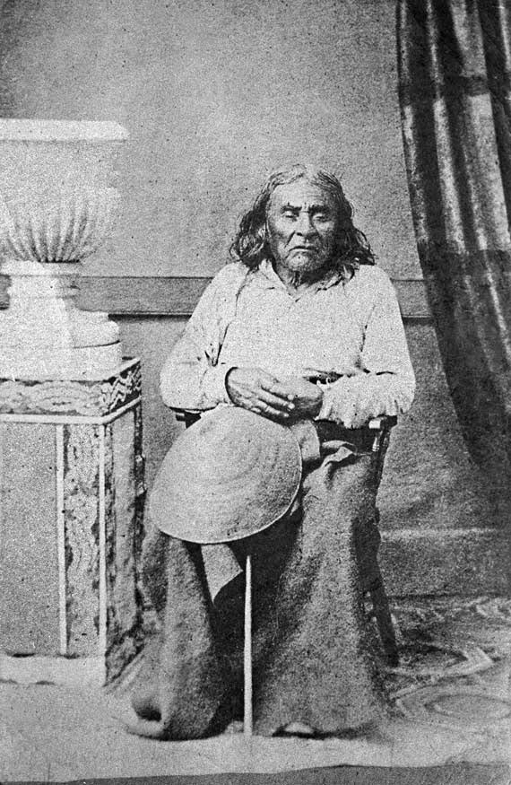
(The city itself, of course, was named after Si’ahl [siʔaɫ], better known in English as Chief Seattle of the Duwamish and Suquamish Tribes.)
The only known photograph of Chief Seattle (1786?–1866), taken by E.M. Sammis in 1864
So, why SW Seattle Street instead of Seattle Street SW?
In Seattle, east–west streets have the directional come first, and north–south avenues have it come last. The Wikipedia article “Street layout of Seattle,” which I helped write, has a more comprehensive description of Seattle’s addressing system, including the answer to this question:
Why was it W Seattle Street in 1907 but SW Seattle Street now?
In 1961, city ordinance 89910 “established a standard system of street name designations” so that in almost all cases streets within a given zone would carry the same directional. West Seattle avenues already carried the SW designation.