The house that was the subject of both articles, 5515 NE Latimer Place, was, according to county records, built in 1925, two years after Latimer’s death — perhaps he had intended to purchase it once it was completed but it was his family who ended up doing so? Or perhaps it was in fact built a few years earlier. At any rate, the Laurelhurst Blog says that “the Latimer Family… re-platted the grounds to be sold in the 1930’s, saving the 20,000+ square foot lot and carriage house for themselves.“ (The recent owner of the house quoted in the PSBJ as saying “Latimer named the street after himself and sub-divided the property” was incorrect, as this happened 12 years after his death.)
Norval Hastings Latimer, 1890. Photograph by Boyd and Braas.
This short street runs just over a tenth of a mile from 50th Avenue NE by St. Bridget Catholic Church in the northwest to NE 50th Street by Villa Academy in the southeast. It was established in 1913 as part of the Montlake Tracts addition by “Magdalena Nicklas, a widow.” Legal advertisements in The Seattle Republican newspaper in 1908 show her husband’s name to have been John Nicklas. Based on this article by Valarie Bunn, this FamilySearch page, this Find a Grave page, plus an item in the November 25, 1941, issue of the Seattle Post-Intelligencer, saying that 20 years earlier “the first woman to homestead on Sand Point, Mrs. Magdalena Nicklas, eighty-two, dies at her home,” we can expand the Nicklases’ biographical information to be Magdalena Kummer, 1839–1921, and Johann “John” Nicklas, 1834–1908, who were farmers in what is now Přimda, Czech Republic, but was then Pfraumberg, Austria–Hungary. They came to the United States in 1867 and to Seattle in 1878, and their land claim covered the 160 acres between what is now NE 45th Street on the south, NE 55th Street on the north, 45th Avenue NE on the west and 55th Avenue NE on the east.
Map of land claims in what is now Laurelhurst, from A History of Laurelhurst by Christine Barrett, published 1981.
This narrow street, which begins at 8th Avenue NW, snakes ⅔ of a mile west through a hilly, forested tract overlooking Puget Sound just north of Broadview Creek. It was established in 1940 as part of the Elford Park addition by Albert Sydney Elford (1867–1956) and his wife, Mae Caniff Elford (1877–1968), both originally from Ontario, Canada.
In Seattle and Environs, 1852–1924, by Cornelius Holgate Hanford, Albert S. Elford is described as “among the foremost representatives of insurance interests in the west,” having been transferred to Seattle in 1911 by the New York Life Insurance Company. He was also a director of the Dexter Horton National Bank; vice president, treasurer and a director of the Best Universal Lock Company; and a member of the First Methodist Episcopal Church, the Rainier Club, the Seattle Golf Club, the Rainier Golf and Country Club, the Elks, the Odd Fellows, and the Masons.
Unfortunately, Elford Park was among the far too many Seattle subdivisions that were created with racial restrictive covenants:
Tracts or parcels of land in this plat shall be used or occupied only by members of the white or Caucasian race, excluding Semites, and no other persons shall be permitted to use or occupy said tracts or parcels, except employees may occupy the premises where their employer resides.
This Queen Anne street runs a mere tenth of a mile north from McGraw Place alongside the Wolf Creek Ravine. As Michael Herschensohn, president of the Queen Anne Historical Society, writes, it was named in 1921 by and for builder John A. Lorentz (né Johan Amandus Lorentzson, 1879–1958), who came to the United States from Sweden in 1903.
This street runs not quite 300 feet from Martin Luther King Jr. Way S in the east to 42nd Avenue S in the west, just south of S Henderson Street. Like nearby Valdez Avenue S and Yukon Avenue S, it was established in 1905 as part of Dunlap’s Supplemental to the City of Seattle, and, in keeping with the Alaska theme, was named after the city of Fairbanks, which had been founded just four years earlier. (Fairbanks itself was named after Indiana Senator Charles Warren Fairbanks [1897–1905], who was vice president under Theodore Roosevelt from 1905 to 1909.)
This short street (just ⅛ of a mile long) connects Martin Luther King Jr. Way S to Yukon Avenue S in Seattle’s Dunlap neighborhood. Established in 1905 as part of Dunlap’s Supplemental to the City of Seattle, it was named after Valdez, Alaska, which was itself named after Spanish naval officer Antonio Valdés y Fernández Bazán. (Other streets in the plat include the above-mentioned Yukon Avenue as well as Tanana Drive, Fairbanks Drive, and Rampart Drive. Tanana Drive is now part of S Henderson Street; Fairbanks Drive is now S Fairbanks Street; and Rampart Drive is now part of S Director Street.)
I haven’t been able to find a specific connection the Hulbert or Dunlap families might have with Alaska, but 1905 was just six years after the Klondike Gold Rush ended, and just four years before the Alaska–Yukon–Pacific Exposition. Seattle’s population went from 42,837 in 1890 to 80,671 in 1900 — an increase of 88% — and much of this was due to its central role in the gold rush as “the premier supply centre and the departure point for the gold fields.”
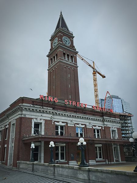
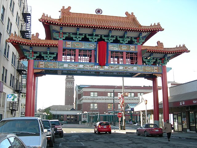
King Street is another of the first streets platted in Seattle by David Swinson “Doc” Maynard in May 1853. It was named after William Rufus DeVane King, a slaveholding Unionist Democratic politician who founded and named Selma, Alabama; was a senator from Alabama from 1819 to 1844 and from 1848 to 1852 (he was ambassador to France in the interim); and was vice president under Franklin Pierce for 45 days in 1853 (he died two days after he returned to the U.S. from Cuba, where he had been convalescing from tuberculosis; King Street was named in his honor 35 days after that).
S King Street begins on the Elliott Bay waterfront at Alaskan Way S and runs ¼ of a mile to King Street Station just past 2nd Avenue S. It resumes at at 5th Avenue S, where it is spanned by the Historic Chinatown Gate, then makes it a full mile to 20th Avenue S, passing through Chinatown and Little Saigon along the way. East of there it exists in various segments, none of which is longer than ⅓ of a mile, and it finally ends at Lakeside Avenue S, where it is one of the String of Pearlsshoreline street ends.
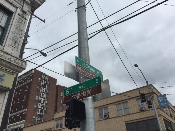
S Jackson Street begins today at Alaskan Way S on the Elliott Bay waterfront and has an uninterrupted 2-mile run as an arterial to 31st Avenue S in Leschi. On the other side of Frink Park, it makes its way the few remaining blocks to Lake Washington as a minor arterial, then a staircase, then a minor street, and finally a shoreline street end, part of the String of Pearls.
Weller Street was among the first streets platted in Seattle by David Swinson “Doc” Maynard in May 1853. It was named after John B. Weller, Democratic senator from California from 1852 to 1857 (Maynard named four streets in his plat after prominent Democratic politicians). Though he wasn’t a slaveowner like President Andrew Jackson or Vice President William R. King, or a future secessionist like Joseph Lane, who was the Southern Democrats’ nominee for vice president in 1860, he was a pro-slavery “Lecompton Democrat” who planned to have California become independent in case of civil war.
S Weller Street begins today at 5th Avenue S and runs ¼ of a mile through the Chinatown–International District to just east of 8th Avenue S, where it, like S Lane Street, is blocked by Interstate 5. It resumes at 10th Avenue S and runs ¾ of a mile to its end at 20th Place S and Washington Middle School.
* As a card-carrying address nerd, I feel compelled to mention that the driveway for the Nippon Kan Theatre/Kobe Park Building at the dead end of S Washington Street is, technically, the northernmost segment of Maynard Avenue S, at least for its first hundred feet.
David Swinson Maynard, ca 1868, photographer unknown
Maynard — unlike Republican Arthur Armstrong Denny, who platted the tract to the north — was a Democrat, and named a number of streets in his plat after prominent Democratic politicians, including the slaveholders President Andrew Jackson and Vice President William Rufus DeVane King; Oregon Territorial Governor Joseph Lane, who went on to be the pro-slavery Southern Democratic candidate for vice president in 1860; and pro-slavery California Senator John B. Weller. I haven’t seen much online about Maynard’s personal racial views, but he was known to have had good relations (given the era) with the local Native Americans, at least. Junius Rochester writes for HistoryLink:
Perhaps one of Doc Maynard’s most enduring qualities, besides his amiability, was his high regard for the local Indians. Chief Seattle was a particular friend, having stated: “My heart is very good toward Dr. Maynard.” Maynard, who knew tribulations in his own life, understood that besides the tools, medicines, guns, and other wonders that the white men had brought to Puget Sound, they also introduced disease, intolerant religions, and the inhospitable idea of private property.
There can be no avoiding his privileged promotion of white settlers at Native Americans’ expense. “They will fight,” he writes on Nov. 4, 1855. “There is no reason why they (sho)uld not, but we must conquer them.”
One hopes that, if Maynard were alive today, he would choose worthier men (and women) to honor than Jackson, King, Lane, and Weller.
Lane Street was another one of Seattle’s first streets, platted on May 23, 1853 by David Swinson “Doc” Maynard. It was named after Joseph Lane, governor of Oregon Territory (which then included what is now Washington) from March 1849 to June 1850. Ten years later, he was the pro-slavery, pro-secession Southern Democratic nominee for vice president, with John C. Breckenridge at the head of the ticket.
S Lane Street begins today at 6th Avenue S just east of the flagship Uwajimaya grocery store, and runs ⅕ of a mile through the Chinatown–International District to just east of 8th Avenue S, where it is blocked by Interstate 5. East of there, it is a path and stairway from 10th to 13th Avenues S, past which it appears in segments of varying lengths until it ends for good at Lakeside Avenue S.
Washington Street was one of Seattle’s first streets, platted on May 23, 1853 by David Swinson “Doc” Maynard and named after President George Washington. Its initial segment begins at Alaskan Way S on the Elliott Bay waterfront and ends half a mile to the east at Kobe Terrace Park. East of Interstate 5 it exists in a number of segments interrupted by schools and parks and finally ends at S Frink Place and Frink Park.
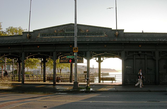
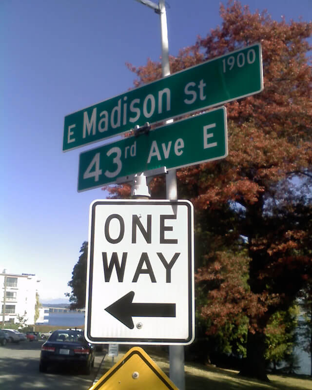
Madison Street — another of Seattle’s “first streets” — was named for James Madison, president of the United States from 1809 to 1817. It is the only street in town that stretches, uninterrupted, from the salt water of Elliott Bay and Puget Sound to the fresh water of Lake Washington.
Madison Street begins on the Elliott Bay waterfront at Alaskan Way and ends 3¾ miles northeast of there at a small fishing pier, just east of 43rd Avenue E and north of Madison Park Beach. Apart from a slight bend to the northeast at 22nd Avenue, it is as straight as an arrow from beginning to end.
Marion Street runs ⅖ of a mile from Alaskan Way to 6th Avenue, where it is interrupted by Interstate 5. It picks up again at 7th Avenue and runs about the same distance to Broadway, where the Seattle University campus begins. East of there it runs in sections of varying lengths until it ends for good at 38th Avenue and Madrona Park.
James Street, one of the first streets platted in Seattle on May 23, 1853, was named by Arthur Armstrong Denny after his younger brother, James Marion Denny (1824–1854). Histories of Seattle report that James was too sick to leave Oregon and come to Puget Sound with the Denny Party and, indeed, he died in the town of Sublimity, Oregon, just a year after the street was named for him. Nothing I have found reports an actual cause of death. Marion Street is also named after this brother.
James Street runs ¾ of a mile from Yesler Way just east of 1st Avenue to an alley just east of Broadway. It appears east of there in a few short stretches and finally as a stairway from 38th Avenue to Lake Washington Boulevard at Madrona Park.
This street runs just over ¼ of a mile from 37th Avenue E in the north, by Lakeview Park, to E Howell Street and 39th Avenue in the south. It was named for George and Otilde Dorffel, who might otherwise be best known for giving Ravenna its name.
In the original 1901 plat of Denny-Blaine-Lake Park, the Dorffel Drive name was given to what is now Madrona Place E, and what is now Dorffel Drive was then 37th Avenue. The change, which took place in 1906, would seem to have been done to eliminate the oddity of 39th Avenue becoming 37th Avenue as it crossed E Howell Street.
This street runs around 650 feet from 34th Avenue E, just north of E Denny Way, to 37th Avenue East. It was established in 1903 as part of Waddell’s Madrona Park Addition to the City of Seattle by, among others, Albert and Florence M. Waddell.
Advertisement for Madrona Park Addition, The Seattle Times, April 7, 1903
This street lies mostly in Columbia City, where its name originated, and Seward Park, with a few blocks in Beacon Hill and even fewer in West Seattle. It almost reaches Puget Sound at Beach Drive SW, and does reach Andrews Bay of Lake Washington at Lake Washington Boulevard S.
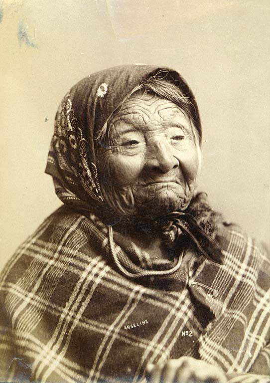
Princess Angeline was born Kikisoblu, the daughter of Si’ahl [siʔaɫ], better known in English as Chief Seattle of the Duwamish and Suquamish Tribes. Her date of birth is unknown; Wikipedia gives it as ca. 1820, whereas this article posted by the Duwamish Tribe, written by elementary school students based on HistoryLink essays, gives it as 1828. She died May 31, 1896.
Princess Angeline received her English name from Catherine Broshears Maynard, wife of David Swinson (“Doc”) Maynard, one of the earliest Seattle settlers. As the HistoryLink Elementary article puts it,
Chief Seattle’s oldest daughter was named Kikisoblu. She became friends with many of Seattle’s founding families. One of her friends was Catherine Maynard. She felt that Kikisoblu should have a name that would let the white settlers know that she was the daughter of a great chief. So she called her Princess Angeline. She thought that name was prettier than the name Kikisoblu.
Photograph of Princess Angeline (Kikisoblu), by Frank La Roche, ca. 1893
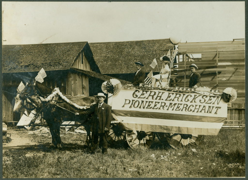
This street, which runs around 675 feet from 35th Avenue NE at NE 135th Street to Lake City Way NE at NE 137th Street, connecting the two arterials, was named, as local historian Valarie Bunn tells us in Gerhard Ericksen’s Good Road, after Norwegian immigrant Gerhard Johan Ericksen (1860, Molde, Norway – 1920, Bothell, Washington).
Parade float, July 4, 1908, for Gerhard Ericksen’s Mercantile, Bothell; Gerhard Ericksen at far left, son George Ericksen at far right
Ericksen, a Bothell merchant and Washington state legislator, was behind the creation of what is now the Washington State Department of Transportation, and the Gerhard Erickson Road (sic) was named in his honor. Bunn writes:
This road preceded the creation of Victory Way (Bothell Way/Lake City Way.)… In Wedgwood today, the Erickson Road route still exists as part of Ravenna Avenue NE north of NE 83rd Street.… as far as NE 110th Street. At the corner where Nathan Hale High School is located… the Erickson Road route took an eastward turn over to what is now 35th Avenue NE. At NE 135th Street, the 35th Avenue NE arterial angles over and merges with Lake City Way NE. The two-block portion from NE 135th to 137th Streets is still called Erickson Place NE.
Why the street is spelled Erickson instead of Ericksen is unknown.
Anna Sophia Brygger, the Norwegian immigrant mentioned in NW Brygger Place, is also the namesake of Magnolia’s Brygger Drive W, a short street that runs not quite a tenth of a mile from 34th Avenue W just north of W Government Way to a dead end at Kiwanis Memorial Preserve Park. Many of the streets on the map below were either never built (Northview Place, Albert Street [Alberta is a typo], Byers Place) or were only partially built (Fort Place, 35th Avenue W, 34th Avenue W, and Brygger Drive itself.)
Map of Lawton Heights Addition, Magnolia, 1912 Baist Atlas
One of his blog posts is on NW Brygger Place, which runs around 650 feet from 26th Avenue NW in the east to 28th Avenue NW in the west, just south of NW 60th Street and the Ballard Community Center and Playfield. Its namesake was Anna Sophia Brygger (1853–1940), an immigrant from Norway, who also named Brygger Drive W in Magnolia after herself. Do check it out, along with the rest of his posts.
Map of Brygger’s 1st Home and 2nd Home Additions, Ballard, 1912 Baist’s Real Estate Atlas
N Clogston Way, which runs a mere 200 feet east from Green Lake Way N to a dead end, between N 54th and N 55th Streets, was named after a Union veteran of the Civil War, as Valarie Bunn of Wedgwood in Seattle History notified me tonight.
John D. Clogston served “with the 9th Regiment, New Hampshire Infantry. On the 13th of December, 1862, Clogston was wounded in battle at Fredericksburg, Virginia, losing part of his right hand. His injury was so severe that he was discharged on February 6, 1863.” He and his bride, Lucinda, moved to Seattle in 1889, just a few months after the Great Seattle Fire; he died 20 years later at the age of 71.
Seattle Times article, January 27, 1903, on naming of what was then Clogston Place, now Clogston Way
Bunn also pointed me in the direction of this Seattle Times article that appeared January 27, 1903, which explains how the street got its name:
Someone, in platting land at the south end of Green Lake, near North Fifty-fifth street, omitted to name a street extending some blocks of a certain addition. The other day when J.D. Clogston called upon the building inspector for a permit to erect a house, he could neither give the name of the street nor the number of his premises. Such an obstacle had never been presented to the building inspector, and the only way to overcome it was to pass an ordinance of council giving a designation to the street. For want of a better name the street was called Clogston Place. Thus it has happened that an humble laborer in the city street department, waking from his dreams this morning, finds himself famous and his name perpetuated in municipal history. Only a few days ago Dewey, of Manila fame, was honored in a similar way by the Seattle City Council.
This street, which runs not quite a tenth of a mile from Ellis Avenue S in the west to 13th Avenue S in the east, was named by Angelo Boitano after himself as part of Boitano’s Supplemental Addition to the City of Georgetown in 1906. (Incidentally, if I ever had the opportunity to name a street after myself, I would call it Lukoff, not Benjamin.)
There isn’t much on the internet about him, but apparently he was interested in chestnut growing, and was in a bad buggy accident in 1908.
July 19, 1908 article in The Seattle Times on buggy accident that injured Boitano
This short street — just over 300 feet long — runs from Airport Way S in the east to Corson Avenue S in the west. It was established in 1903 as Carstens Street, part of Carstens’ Addition to Georgetown, “filed for record at the request of Thomas Carstens on the 4[th] day of June 1903 at 49 Min. past 9 A.M.” This is the first time I’ve seen the actual time of filing on a plat!
Thomas Carstens, born in 1865 in Husum, Germany, near Denmark, came to the Pacific Northwest in 1884, and in 1890 established a butcher shop with his brother, Ernest, which later grew into the Carstens Packing Company.
Clinton A. Snowden, author of History of Washington: The Rise and Progress of an American State, wrote in 1911 of Carstens:
Mr. Carstens, besides being president of the Carstens Packing Company, is president of the Tacoma Wheat Land Company, president of the Pacific Oil Mills, and director of the National Realty Company of Tacoma. He is a member of the Seattle Chamber of Commerce, Seattle Commercial Club, Arctic Club of Seattle, Seattle Manufacturers’ Association, Duwamish River Improvement Club, Tacoma Commercial Club, and Tacoma Chamber of Commerce.
This street, which runs just under 400 feet from Yesler Way and 3rd Avenue S in the northwest to S Washington Street and 4th Avenue S in the southwest, cutting a skewed diagonal through the block, is named for Father Francis X. Prefontaine, Seattle’s first Catholic priest. In 1870, he founded Seattle’s first Catholic church, Our Lady of Good Help, on the block Prefontaine Place cuts through today.
Thomas Prosch, who named Conkling Place W after his mother, didn’t neglect to name something after himself. Prosch Avenue W runs about ¼ mile from W Barrett Street in the north to 13th Avenue W in the south. It appears as Prosch Place in Prosch’s Queen Anne Addition to the City of Seattle in 1909. Six years later, Prosch was killed in a car crash that also took the lives of his wife, Virginia; painter Harriet Foster Beecher; and Margaret Lenora Denny, namesake of Lenora Street.
Thomas Wickham Prosch, 1890
Portion of Prosch’s Queen Anne Addition to the City of Seattle, 1909
This street runs just over a thousand feet from 10th Avenue W and W Bertona Street in the northwest to 8th Avenue W and W Dravus Street in the southeast. It was named after Susan Conkling Prosch, mother of Thomas Prosch, who filed Prosch’s Queen Anne Addition to the City of Seattle in 1909. (Prosch was a noted local journalist and historian, who didn’t neglect to name Prosch Avenue W after himself.)
Susan Conkling Prosch, 1897
Conkling Place was one of the streets retained when George E. Morford and Gertrude Keen Morford filed their plat of Queen Anne Park in 1926. The Queen Anne Historical Society has an extensive article on the latter subdivision, which was among those in Seattle with all-too-common racial restrictive covenants, in this case excluding Blacks and Asians.
Portion of Prosch’s Queen Anne Addition to the City of Seattle, 1909.
This street runs ¼ mile from 1st Avenue S in the west to 4th Avenue S in the east. West of 1st, it’s S Atlantic Street — its original name — and east of 4th, it’s the beginning of Interstate 90. It is part of State Route 519, a short highway that connects I-90 to Washington State Ferries’ Colman Dock.
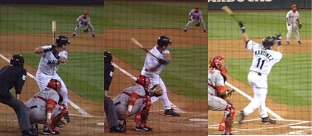
Edgar Martínez was a member of the Seattle Mariners baseball team from 1987 to 2004. This stretch of S Atlantic Street was renamed in his honor the year he retired.
Now — why is it Edgar Martinez Drive S instead of S Edgar Martinez Drive, since east–west streets in Seattle have their directional designators at the beginning? I asked Paul Jackson this in 2005. Jackson, who was then the Seattle Department of Transportation’s manager of traffic, signs, and markings, responded:
I appreciate your desire to see our City’s sign system remain consistent.… But ultimately, there is nothing requiring such a naming convention in the Seattle Municipal Code.… In this case, those proposing the street name change wanted to see Edgar Martínez’s name out front. Because this is only a three-block stretch of street (from 1st Avenue S to 4th Avenue S), and does not have any addresses along it, the decision was made to veer slightly from the typical naming convention. The term “drive” was agreed upon to evoke Mr. Martínez’s batting skills at the plate.


.jpg)