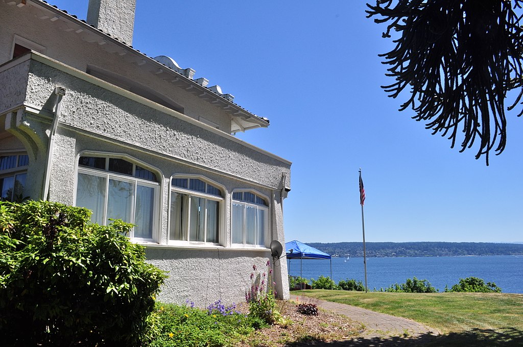
This short street in Seattle’s Windermere neighborhood runs from 60th Avenue NE and NE 55th Street in the southwest to 63rd Avenue NE and NE 57th Street in the northeast. It was likely named after Lochkelden, the mansion built in 1907 for Rolland Herschel Denny (1851–1939) and his wife, Alice Martha Kellogg Denny (1857–1940). Rolland was just six weeks old when the Denny Party landed at Alki Point in November 1851. Lochkelden — owned since 1974 by Sun Myung Moon’s Unification Church — was itself named for Lake Washington, of which it has a commanding view (loch being Scottish for ‘lake’) and its owners: Kellogg and Denny.
This street, which originates along with the rest of the heart of Ballard in the 1889 plat of Gilman Park, was named for šilšul, a village of the shill-shohl-AHBSHpeople along what is today known as Salmon Bay. Meaning ‘tucked away inside’ in the Lushootseed language, it is one of two remaining Native place names in Seattle, the other being Licton Springs (liq’təd).
Why, then, is the Shilshole Bay name applied to the body of water west of the Ballard Locks? Shouldn’t Shilshole Avenue, Shilshole Bay, and šilšul all be in the same location? According to Edmond Stephen Meany’s 1923 Origin of Washington Geographic Names, citing early settler Arthur A. Denny’s 1888 Pioneer Days on Puget Sound,
In December, 1852, Arthur A. Denny, knew the bay as “Shilshole.” It was later changed to Salmon Bay because it was thought to be frequented by Salmon.
Today, Shilshole Avenue NW begins at 14th Avenue NW in the east and goes ⅘ of a mile northwest to 24th Avenue NW, just short of NW Market Street.
This winding, semicircular street runs almost ⁹⁄₁₀ of a mile from 15th Avenue NW and NW 100th Street in the east to Triton Drive NW, NW Neptune Place, and NW 100th Street in the west, descending 300 feet to Puget Sound along the way. Named after the Blue Ridge community, it was established in 1930 as part of the plat of Blue Ridge, an Addition to King County, Washington (rather than to Seattle, as the far northwestern section of the city wouldn’t be annexed until 1953).
No property in said Addition shall at any time be sold, conveyed, rented, or leased in whole or in part to any person or persons not of the White or Caucasian race. No person other than one of the White or Caucasian race shall be permitted to occupy any property in said addition or portion thereof or building thereon except a domestic servant actually employed by a person of the White or Caucasian race where the latter is an occupant of such property.
Uniquely, as they note, the restrictions on membership in the Blue Ridge Club, established in 1941 and forerunner of today’s homeowner association, were slightly different:
No Asiatic, Negro or any person born in the Turkish Empire, nor lineal descendant of such person shall be eligible for membership in the Club.
They speculate this restriction on Ottoman citizens and descendants thereof was aimed at Sephardic Jews (Seattle is said to have the third largest population in the country), although if that is the case, I wonder why the restriction wasn’t against all Jews, as was done in Broadmoor and the Sand Point Country Club. At any rate, it would seem to have affected not only Sephardim but Arabs, Levantines, and North Africans in general. These restrictions were finally lifted in 1989, decades after they became unenforceable.
Blue Ridge says that “The development of the Blue Ridge community and the government-engineered policies of segregation brings some controversy to the early days of the neighborhood. However, today Blue Ridge is diverse and welcoming to anyone wanting to share in all that it has to offer.” As the interactive map on the Seattle Civil Rights & Labor History Project page on Blue Ridge shows, though, the covenants had the desired effect — the neighborhood is still around 81% white, 12% Asian… and just 0.5% Black.
As far as being an “exclusive” neighborhood goes, Blue Ridge is more like Windermere than the above-mentioned Broadmoor and Sand Point Country Club; it features a private waterfront park, but all the streets are public, and there are even two very small public parks (Blue Ridge Circle and Blue Ridge Places) plus the wooded Mary Avenue Trail to the southern boundary of Carkeek Park.
Ten or so years ago I saw a Private Property sign at the trailhead, put up by the Blue Ridge Club, but it was gone the next time I visited — I can’t remember if I complained or someone else did. (The woods are private, but the trail is Mary Avenue NW right-of-way.) This wasn’t in the original plat, but according to an old Flickr chat I had with Andreas “Severinus” Breuer, “there was apparently a WPA project approved to install a 30′-wide gravel road between 100th and 110th (apparently now NW Carkeek Park Road).… I imagine the ravine would look quite different if a 30′ gravel road had been put in, so presumably this plan wasn’t carried out. But a 1940 engineering map shows a surveyed ROW from 105th to the Carkeek border, and in Carkeek there seems to be a route that follows the WPA route (Clay Pit Trail > Hillside Trail > Brick Road Trail > Road). Perhaps the trail that exists today was made by the original surveyors or by WPA men?”
This short street runs just over 750 feet from Triton Drive NW in the west to NE 98th Street in the east, just west of 24th Avenue NW. It was established in 1926 as part of North Beach, an Addition to the City of Seattle; at the time, it extended farther south, but that section is now 26th Avenue NW. The beach being referred to is on Puget Sound, across the BNSF Railway tracks from what is now NW Esplanade.
Although it bears the neighborhood’s name, houses along North Beach Drive are actually only eligible for associate, not full, membership in the North Beach Club, as the community boundary map shows. This is because the club, which originated in 1927 as the Golden View Improvement Club, was formed by and for residents of the Golden View and Golden View Division № 2 subdivisions, platted in 1924 and 1926, respectively. (According to state records, the GVIC was administratively dissolved in 1982 and merged into the North Beach Club [founded 1990] in 2006. [No word on what entity managed affairs from 1982 to 1990.]) In 1930, the club took over responsibility for the subdivisions’ water system from the developer, who as part of the deal deeded 1,500 feet of Puget Sound beach to the organization. It is this private beach, accessible via a short path from NW Esplanade at 28th Avenue NW, that is the North Beach Club’s primary raison d’être today, the water system having been hooked into the city supply long ago. Today’s associate members are the “descendants” of those who were interested in the Golden View additions’ water system 91 years ago but lived outside the subdivision boundaries — including residents of NW North Beach Drive.
This street runs just shy of a mile through the gated Broadmoor neighborhood and golf course from its south entrance at E Madison Street at 36th Avenue E to its north entrance at E Foster Island Road.
An article in the May 18, 1924, issue of The Seattle Times noted that “[Broadmoor’s] roadways will not be public streets as in other residential sections of the city,” calling this “one of the unmatched features of this community,” and adds that “certain restrictions have been named both as to the class of residences that may be constructed as well as to those who will be admitted to membership.” The entire community being private was a first for Seattle, and in fact has never been repeated — the Sand Point Country Club was also established in the late 1920s, but was in unincorporated King County at the time and wasn’t annexed until 1953, whereas Windermere, established within Seattle city limits around the same time, was in fact platted as a traditional neighborhood, albeit one with private amenities.
Speaking of those “certain restrictions,” by the way, it seems that even in the 1920s one could not say openly in the press what one really meant. But Broadmoor deeds and their racial restrictive covenants are public record:
No part of said property hereby conveyed shall ever be used or occupied by any Hebrew or by any person of the Ethiopian, Malay or any Asiatic Race, and the party of the second part, his heirs, personal representatives or assigns, shall never place any such person in the possession or occupancy of said property or any part thereof, nor permit the said property, or any part thereof, ever to be used or occupied by any such person, excepting only employees in the domestic service on the premises of persons qualified hereunder as occupants and users and residing on the premises.
Broadmoor: Restricted Residential Park With Golf Course, 1924. Courtesy of the Seattle Municipal Archives, Identifier 1423.
The origin of the Broadmoor name is not entirely clear. Did it have anything to do with the Broadmoor Golf Club in Colorado Springs, which opened in 1918? Or with the moors of Scotland, home of modern golf? The above-mentioned Seattle Times article, which is so similar to one in the Seattle Post-Intelligencer it must have been based on a Puget Mill Company press release, doesn’t say. (My friend, local historian Joe Mabel, notes the best-known Broadmoor in the U.K. is actually a high-security psychiatric hospital founded in 1863.) It may just be that “Broadmoor” was considered to be “elegant.” Perhaps the answer lies somewhere in the personal papers of Edwin Gardner Ames, Puget Mill president and one of the developers of Broadmoor along with Grosvenor Folsom and George W. Johnson.
This semicircular street in Seattle’s Windermere neighborhood runs just over a mile from Sand Point Way NE between NE 55th Street and NE 58th Street in the west to just north of NE 61st Street in the east, at the southern end of Magnuson Park. The street and neighborhood itself were named after Windermere, the largest lake in England.
Plat of Windermere, an Addition to the City of Seattle, 1937. Courtesy of the Seattle Municipal Archives, Identifier 1628.
Unfortunately, as with far too many Seattle subdivisions, Windermere deeds came with racial restrictive covenants. The relevant part of this deed reads as follows:
Said property shall not be conveyed, sold, rented, or otherwise disposed of, in whole or in part, to, or be occupied by, any person or persons except of a white and Gentile race, except, however, in the case of a servant actually employed by the lawful owner or occupant thereof.
Notably, although membership in the Windermere Corporation does come with access to the private Windermere Park and Beach Club, all streets in the neighborhood are public — it is a gated community only in spirit.
Lakeview Boulevard E, which originated in David and Louisa Denny’s 1886 East Park Addition to the City of Seattle, is named for its view of Lake Union to the west. For a time part of the Pacific Highway (now routed onto Aurora Avenue N), it begins today at an overpass over Interstate 5 at Eastlake Avenue E and Mercer Street and goes a mile north to Boylston Avenue E and E Newton Street.
Interstate 5 blocks the view of the lake from much of the northern section of the street, but the southern section’s view is still more or less intact.
Forming a trio with Eastlake Avenue and Northlake Way, Westlake Avenue is so named for running along the western shore of Lake Union. Beginning today at Stewart Street between 5th Avenue and 6th Avenue, just north of McGraw Square, it runs 2½ miles north to 4th Avenue N between Nickerson Street and Florentia Street — the south end of the Fremont Bridge.
Westlake Avenue once started a couple of blocks to the south, at 4th Avenue and Pike Street, and based on the quarter section map, it appears that its former route through Westlake Park between Pike Street and Pine Street is still public right-of-way as opposed to park land. (The portion between Pine Street and Olive Way was vacated in 1986 to make way for the Westlake Center mall, which opened in 1988, and the portion between Olive Way and Stewart Street was closed in 2010 to allow for the expansion of McGraw Square.)
Westlake was extended south to 4th and Pike from Denny Way in 1902 (one former mayor has called for that extension to be closed to cars); the original Westlake Avenue (now, properly, Westlake Avenue N) was created in 1895 as part of the Great Renaming ordinance, Section 5 of which reads
That the names of Rollin Street, Lake Union Boulevard and Lake Avenue from Depot Street [changed by the same ordinance to Denny Way] to Florentia Street, be and the same are hereby changed to Westlake Avenue.
Rollin Street, the southernmost portion, was named for Rolland Herschel Denny (1851–1939), the youngest member of the Denny Party at just six weeks old. In its honor, an apartment complex that opened at the corner of Westlake and Denny in 2008 is named Rollin Street Flats.
Having covered Northlake, Eastlake, and Westlake so far, one might ask: why is there no Southlake?
There does appear to have been a Southlake Avenue for a time — 1909 to 1924 or so, based on the last mention of it I could find in Seattle newspapers, an article in the August 8, 1924, edition of The Seattle Times on a car crash that had taken place a number of weeks earlier. Now the northern section of Fairview Avenue N, it extended from the intersection of Valley Street northwest to E Galer Street and Eastlake Avenue E, “thus eliminating the present grade on Eastlake for University traffic” in the words of a real estate advertisement in the August 23, 1914, edition of the Seattle Post-Intelligencer. But why the Southlake name disappeared seems clear: once it was decided to extend the Fairview name along the shore lands, there was no other appropriate road to carry it. The northern and eastern shores of Lake Union are just shy of 2 miles long each, but since the lake is shaped like a ? (and, surprisingly, like a uterus if Portage Bay is included) there is hardly any southern shore to speak of — only about ¼ mile.
As for the neighborhood name, I’m not sure why South Lake Union came to be used instead of Southlake. Perhaps it’s as simple as the lack of a similarly named street to “anchor” the neighborhood.
Like NE Northlake Way, Eastlake Avenue E is so named because it runs along the shore of Lake Union — in this case, obviously, the eastern one. It, too, was earlier named Lake Avenue (in part), but this was changed as part of the Great Renaming of 1895. Ordinance 4044, Section 6 reads
That the names of Albert Street, Waterton Street, Lake Avenue and Green Street from Depot Street [changed by the same ordinance to Denny Way] to the shore of Lake Union at the northerly point of the Denny–Fuhrman addition, be and the same are hereby changed to Eastlake Avenue.
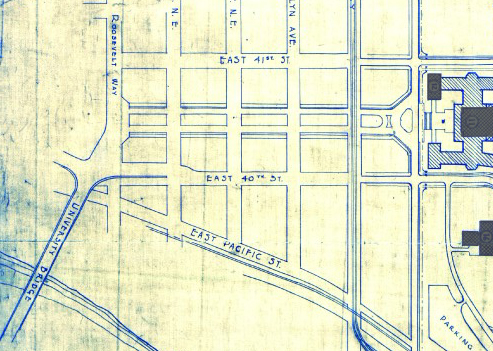
Today, Eastlake, at 2⁹⁄₁₀ miles in length, extends slightly farther north and south than the roadway mentioned in the ordinance. It starts in the south at the intersection of Court Place and Howell Street as Eastlake Avenue, then becomes Eastlake Avenue E a block north as it crosses Denny Way. From here to just south of E Galer Street it divides the Avenue: E; Street: E section of town from the Avenue: N; Street section. Just north of Portage Bay Place E it crosses Lake Union as the University Bridge, then continues on as the one-way–northbound Eastlake Avenue NE to 11th Avenue NE just north of NE 41st Street. (Southbound, it is fed by Roosevelt Way NE at NE Campus Parkway.)
Eastlake, like Fairview and Boren Avenues, is one of the few north–south streets in Seattle to have three different directional designations.
As explained in NE Boat Street, NE Northlake Way was originally Lake Avenue in the 1890 Brooklyn Addition to Seattle, so named because it ran along the northern shore of Lake Union. I couldn’t find an ordinance changing its name from Lake Avenue (used elsewhere, notably for what are now Westlake Avenue and Fremont Avenue N and for part of Eastlake Avenue E) to Northlake Avenue, but the latter name begins to appear in local newspapers in 1901. (Complicating matters slightly, the street appears as North Lake Avenue in the state’s 1907 plat of Lake Union Shore Lands.) Northlake Avenue began being referred to as Northlake Way in 1935, and this was made official in 1956.
Today, NE Northlake Way begins at the west end of NE Pacific Street under the University Bridge at Eastlake Place NE, and continues 1½ miles west to just shy of the Aurora Bridge, where it becomes a private road through formerly industrial land developed by the Fremont Dock Company into a business park. (The Puget Sound Business Journal and The Seattle Times have good articles on how over the years Suzie Burke transformed her father’s Burke Millwork Co., which opened in 1939, into what is today home to local offices for Google and Adobe and corporate headquarters for Tableau and Brooks Sports, among other tenants.) This private roadway continues for ⅖ of a mile beyond the end of the public right-of-way to the intersection of N Canal Street, N 34th Street, and Phinney Avenue N.
NE Northlake Way once began ⅖ of a mile further east, at NE Columbia Road on the University of Washington South Campus, but this stretch was changed to NE Boat Street in 1962, not without some controversy.
The Director of Highways is hereby authorized and directed to select and locate a suitable and fitting street and highway approach to the University of Washington campus in the City of Seattle, from Roosevelt Way to Fifteenth Avenue northeast, including an underpass beneath the surface of Roosevelt Way, and necessary approaches to said underpass.
(A separate section appears to have been responsible for the creation of Stadium Way in Pullman as an approach to Washington State University.) A Seattle ordinance passed the same year committed the city to build and maintain the road, as required by the law, and NE Campus Parkway opened in 1950 — HistoryLink refers to it as a “long-proposed ceremonial gateway to the University.” In 1954, the roadway was deeded to the city.
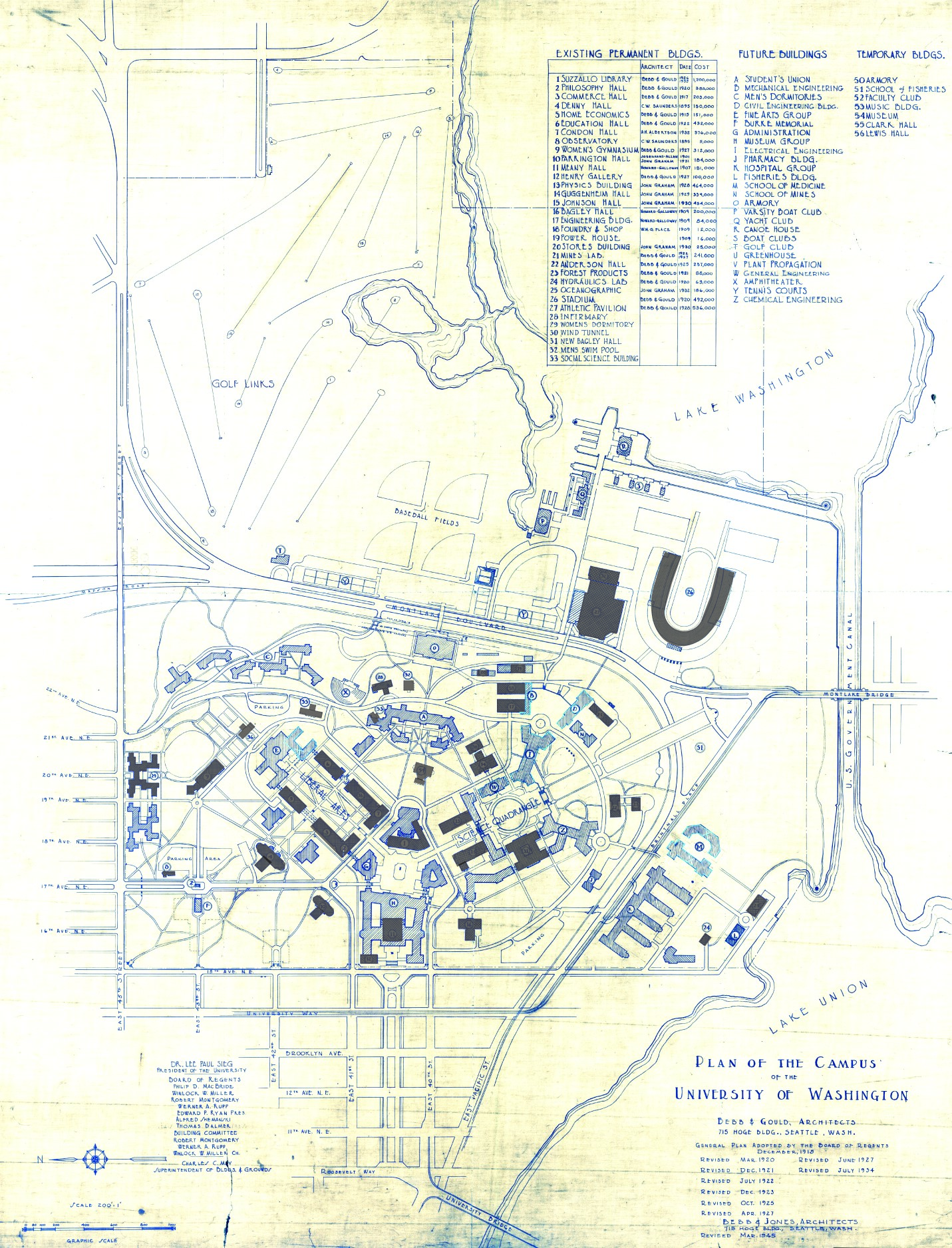
Portion of the Regents Plan showing planned route of Campus Parkway
In 1925 Bebb and Gould proposed a revision to their earlier Regents Plan of 1915, which included a formal boulevard that extended from the University to the west to serve as a principal entry to the campus from the city. Campus Parkway, the formal axis envisioned in the Regents Plan to the west, was constructed finally in the 1940s. It extended the University campus into its surrounding city neighborhood in a monumental and somewhat strident manner. Construction in the 1970s of an underground parking garage, below the Central Quadrangle [actually the Central Plaza, or Red Square], provided a primary vehicle entry south of Denny Hall, and reduced vehicular traffic along the campus ring road.
Traffic to and from lower campus and the lower University District via the University Bridge does necessarily take NE Campus Parkway, but it hardly functions as a gateway, ceremonial or otherwise. The entrance to the above-mentioned parking garage is at NE 41st Street, a block to the north; the west entrance to campus is a block to the south at NE 40th Street, which turns into W Stevens Way NE. One must take a narrow pedestrian bridge over 15th Avenue NE to walk from the parkway onto campus. The pedestrian-only southeast entrance at Rainier Vista and the north entrance at 17th Avenue NE, which turns into Memorial Way NE, fulfill the function far better.
Not even the UW Visitor Center is on NE Campus Parkway, having moved to Odegaard Library a number of years ago. Schmitz Hall, one of the university’s main administrative buildings, remains, between University Way NE and 15th Avenue NE, and with it the Office of Undergraduate Admissions and the Office of the University Registrar — and the university’s “generic address for forms,” 1410 NE Campus Parkway.
(An aside — NE Campus Parkway was once home to the International Friendship Grove of Trees [see articles by Arthur Lee Jacobson and Dick Falkenbury] but many of the trees have since died or been removed.)
To reach their homes, residents of Bay Terrace — east of Lawtonwood and west of Land’s End at the northern tip of Magnolia — must drive through Discovery Park. Within the park, their street (the narrow neighborhood only has one) is known as Bay Terrace Road, but changes to 42nd Avenue W north of the park boundary. Similarly to Lawtonwood Road, it does not appear to have been officially so designated until 2007, when ordinance 122503 was passed. Also similarly to Lawtonwood Road, it carries no directional designation, since it is a park boulevard.
Bay Terrace Road runs ¼ mile north from Lawtonwood Road just west of 40th Avenue W, and then becomes 42nd Avenue W, which continues on for another ⅕ of a mile to a viewpoint overlooking Shilshole Bay.
This street, which runs ⅕ of a mile from 30th Avenue NE in the northwest to the “five corners” intersection with NE 45th Street, NE 45th Place, and Mary Gates Memorial Drive NE, was created in 1907 as part of the Exposition Heights addition. Four years later, the street was extended southeast of NE 45th Street through University of Washington property to NE 41st Street. However, in 1995 that portion was renamed Mary Gates Memorial Drive NE.
As can be seen in the map below, it did once parallel Union Bay; however, when the Montlake Cut of the Lake Washington Ship Canal opened in 1916, the lake and bay dropped by 8.8 feet to match the level of Lake Union and this was no longer waterfront property. The southwest corner of this map is now entirely devoted to commercial and residential use.
Portion of plat map of Exposition Heights showing Union Bay and Union Bay Place
Union Bay itself was named in 1854 by settler Thomas Mercer, with the idea that it and Lake Union, which he also named, would one day be part of a connection from Lake Washington to Puget Sound. As mentioned above, this did end up happening 62 years later.
Pullman Avenue NE begins as an extension of NE 55th Street east of Princeton Avenue NE and goes ⅓ of a mile northeast to NE 60th Street, where it becomes 52nd Avenue NE.
An article in the July 8, 1928, issue of The Seattle Times describes the new subdivision of Hawthorne Hills thus:
The property is situated on a “hogback” between East 55th and East 65th Streets just east of 35th Avenue Northeast.… It is the largest single piece of undeveloped residence property in the city limits.… Because of its proximity to the University of Washington a community center at the highest point on the property has been designated “University Circle.” At this point, 200 feet in diameter, the principal thoroughfares, named after well-known universities and colleges, converge.
University Circle park is ringed by 400-foot-long University Circle NE, which is approximately 125, not 200, feet in diameter. Vassar Avenue NE, Ann Arbor Avenue NE, and Princeton Avenue NE converge on the circle, while Wellesley Way NE, Stanford Avenue NE, Purdue Avenue NE, Pullman Avenue NE, NE Tulane Place, and Oberlin Avenue NE curve through the rest of the neighborhood. (There does not appear to be any organizing concept behind the selection of schools other than the fact they are institutions of higher education. Pullman and Ann Arbor represent state schools; Princeton, Stanford, Purdue, and Tulane private schools; and Vassar and Wellesley women’s colleges; but why these in particular were chosen, I am not sure. Incidentally, Dartmouth, Harvard, Cornell, Yale, Columbia, and Amherst were already in use elsewhere.)
Hawthorne Hills sign, January 28, 2003. Courtesy of the Seattle Municipal Archives, identifier 141197
Unfortunately, Hawthorne Hills — named for Hawthorne Kingsbury Dent, founder of what is today Safeco Insurance — was among the subdivisions in Seattle to which the developers attached racially restrictive covenants. In fact, according to the Seattle Civil Rights and Labor History Project, “Seattle’s first known racial restrictive covenant was written in 1924 by the Goodwin Company,” which also developed Hawthorne Hills, and
No property in this subdivision could be “sold, conveyed, rented, nor leased, in whole or in part, to any person not of the White race; nor shall any person not of the White race be permitted to occupy any portion of said lot or lots or of any building thereon, except a domestic servant actually employed by a White occupant of such building.”
S River Street is just ½ a mile long, and none of it parallels the Duwamish River. The reason behind this is the same reason S Front Street is perpendicular to the waterway — the rechanneling of the Duwamish River that began in 1913. In Joseph R. McLaughlin’s Water Front Addition to the City of Seattle, filed in 1906, Front Street had a horseshoe shape. North Front Street is today’s Front Street, and South Front Street was changed to River Street in 1907, when West Seattle was annexed to Seattle. The Baist Atlas depiction of the Oxbow, below left, is from 1912, so has the modern name.
Today’s S River Street begins at 7th Avenue S and goes ½ a mile west, ending at 1st Avenue S, below the 1st Avenue S Bridge.
Plat of an Addition to the Town of Seattle as Laid Out by A.A. Denny, November 16, 1861
Territorial University of Washington on opening day, November 4, 1861
Even though the University of Washington moved to its current location on Portage and Union Bays in 1895, the name was not changed. Nor did the university relinquish the land, though not for lack of trying. This turns out to have been fortunate. The UW owns the Metropolitan Tract to this day, and it earned $25 million in rent on the property during fiscal year 2020 alone.
The street, which originally ran from Front Street (now 1st Avenue) to the university campus, just northeast of 3rd Avenue, today begins at Alaskan Way on the Elliott Bay waterfront, and makes it just one block, to Western Avenue, before it becomes the Harbor Steps. From 1st Avenue, it’s about a third of a mile to 7th Avenue, where University Street is blocked by Interstate 5. It resumes at 9th Avenue and goes for another third of a mile to Boylston Avenue.
Portion of King County quarter section maps covering Metropolitan Tract
Incidentally, you’ll notice in the map above that 4th and 5th Avenues between Seneca and Union Streets, as well as University Street between 4th and 5th Avenues, plus half a block on either end, are marked private way subject to public use — long term grant of use for street purposes. This fact — that the University of Washington still owns all the land within the Metropolitan Tract and never formally dedicated those streets to the public — was something I never knew until I started taking close looks at King County’s quarter section maps as part of my local history research. It might seem an academic distinction, but as The Seattle Timesreported in 2015, there are very real financial consequences.
In 2008… the UW wanted the city to interpret the tract as one undivided lot, streets and all. That novel argument would benefit the UW in calculating the development footprint, or base.… The bigger the base, the logic went, the more square footage a developer could build before triggering affordable-housing fees under the city’s formula.… The university held a heavy hammer in negotiations. Because the UW owned development rights for the land under Fifth Avenue and University Street, it could make the city compensate it, one way or another, for using those streets.
This street runs a tenth of a mile along the Bitter Lake waterfront from N 134th Street to the grounds of Broadview-Thomson K-8 School and Bitter Lake Playground. It was established in 1923 as part of Bitter Lake Villa Tracts.
Bitter Lake itself was so named because, as HistoryLink puts it, “A small, lake-bound sawmill operation at the southwest corner of Bitter Lake contracted with the Puget Mill and Brown Bay Logging Company to process their lumber cut from nearby forests. The tannic acid from logs dumped into the lake was so bitter that horses refused to drink from it, thus giving the 20-acre pond its name.” Its native name is čʼalqʼʷadiʔ, meaning ‘blackcaps on the sides’.
This street, which runs about ¼ mile from Lake Washington Boulevard E to the beginning of the Foster Point Trail, all within the Washington Park Arboretum, was without a name until 1968, when it was named for the island in Union Bay to which it led. (It remained unsigned until a few decades later, however. There was no sign at the intersection until at least the 1990s, as I know since my parents’ house was at the south end of the Arboretum and I drove or biked by there weekly, if not more often, while I was growing up.)
Foster Island is known by the Duwamish tribe, who once used it as a burial ground, as Stitici, or ‘little island’. It was named by the settlers for Joel Wellington Foster, who came to Washington in the 1870s from St. Joseph, Missouri. He is said to have donated the island to the city in one HistoryLink article, but another says the city bought it in 1917.
This street, established in 1991 as part of the development of the Elliott Bay Marina at the southern foot of Magnolia Bluff, runs ⅖ of a mile west from 23rd Avenue W to just shy of the 30th Avenue W street end beach.
While the origin of its name may not be interesting, the story of its establishment is a bit more so:
The marina itself began the permitting process in 1983, but lawsuits delayed its creation for nearly a decade. The Muckleshoot Indian Tribe and Suquamish Tribe sued to block its construction on the basis that “construction of the Marina would eliminate a portion of one of their usual and accustomed fishing areas in Elliott Bay and thus would interfere with their treaty right to fish at the Marina site.” Homeowners on the bluff above intervened on the side of the developers, as “the area has had numerous major landslides that have left several homes at the crest of the bluff at risk and have repeatedly caused breaks in a trunk sewer line located at the base of the bluff.… The Marina construction includes the placement of 500,000 cubic yards of fill at the toe of the bluff, which would stabilize the area.” Eventually, a settlement was reached, which “calls for ongoing fisheries-related expenses paid to the tribe, which will be funded by a percentage of the moorage income.… [the] ‘Indian Treaty Surcharge.’”
I believe this was the last major fill operation within Seattle city limits. Such a development would be all but unthinkable today.
The marina was built on tidelands where W Lee Street and Puget Avenue W were platted but never built. They were vacated and W Marina Place was established. When it came to naming the access road, the developers originally proposed W Marina Boulevard, contending that as the road fell between the W Oakes Street right-of-way and the former W Lee Street right-of-way, it wasn’t a violation of the city’s principle of maintaining street grid names as much as possible. This was initially rejected by the city, which preferred W Lee Street, but after further discussion, W Marina Place was settled on. An interesting point the developers made was that as W Lee Street had never physically existed in Magnolia, though it had been platted there, calling the access road W Lee Street could actually be confusing, as “people familiar with Seattle streets know that there is no W Lee Street on Magnolia. Rather, they know W Lee Street as being on Queen Anne Hill.” Still, though, I have to believe they were more interested in their own vanity — Marina Boulevard? — than any particular concern for folks’ ability to navigate.
For some reason, the public street ends just feet from the 30th Avenue W street end beach. I’m not entirely sure why that is; I don’t think the marina is opposed to public access to the beach; otherwise, they wouldn’t be in favor of the Magnolia Trail project, which would connect W Marina Place to W Galer Street, 32nd Avenue W, and thence to Magnolia Village.
This street runs 1¼ mile from NE Pacific Street in the south to NE Ravenna Boulevard and Cowen Park in the north. Until 2001, it was a block longer, starting farther south at NE Boat Street, but that portion was vacated as part of the development of the University of Washington campus.
Originally Columbus Avenue and then 14th Avenue NE, it was renamed University Way in 1920 after the University of Washington, which had moved to the neighborhood from its original home downtown in 1895. As local historian Paul Dorpat explains in this HistoryLink essay,
[In 1919] the University Commercial Club… ran [a contest] to rename 14th Avenue…. Club member Arthur Quigley’s “University Way” won the street name contest easily. To deflect any charges that the contest was fixed, Quigley donated the prize money to charity.
Even though it’s been a “way” for 101 years now, to locals University Way has always been, and always will be, “The Ave.” And that in itself will always cause some confusion, as this street sign demonstrates.
This street, which runs ³⁄₁₀ of a mile from Fuhrman Avenue E to E Allison Street, was established as an alley in 1890 as part of the Denny–Fuhrman Addition to the City of Seattle, but only received a name in 1936. It was named for Portage Bay, the eastern arm of Lake Union, which it parallels. Portage Bay was in turn named for the portage from Union Bay (part of Lake Washington) to Lake Union over the Montlake Isthmus, which is today the Montlake Cut of the Lake Washington Ship Canal.
There are only a handful of islands within Seattle city limits, and of them just one — Harbor Island — is large enough to have streets on it. But Island Drive S isn’t on Harbor Island — rather, it’s along the shore of Lake Washington, 5½ miles to the southeast. What gives?
As it turns out, Island Drive once was on an island — Pritchard Island. Known as tleelh-chus (‘little island’) by the Duwamish tribe, it was bought in 1900 by Alfred J. Pritchard (grandfather of Joel Pritchard, who was a congressman from Washington state in the 1970s and 1980s and its lieutenant governor in the 1980s and 1990s). In 1916, Lake Washington was lowered by 9 feet as part of the construction of the Lake Washington Ship Canal, and Pritchard’s island became part of the mainland.
It’s still known as Pritchard Island, though. Today, Pritchard Island Beach, Rainier Beach Urban Farm and Wetlands, and Be’er Sheva Park separate the island from the mainland.
Occidental Avenue S, which begins at Yesler Way in Pioneer Square, is one of those Seattle streets whose names extend into the suburbs. It makes its southernmost appearance at S 197th Street in Des Moines.
It received its name in 1895 as part of the Great Renaming — it had originally been S Second Street. It once had a partner, Oriental Avenue, to the east (originally S Fourth Street), which is today 3rd Avenue S. “Oriental,” of course, means “Eastern,” as “Occidental” means “Western.” (I haven’t been able to determine just when Oriental Avenue became 3rd, but it was last mentioned in The Seattle Times on October 17, 1920.)
And why this particular pairing? The Occidental Hotel, which once overlooked the beginning of Occidental Avenue, is almost certainly the reason, but it’s not spelled out in the ordinance.
This Interbay street, established in 1910 as Lawton Way, runs ¼ mile northwest from 15th Avenue W to the BNSF Railway’s Balmer Yard. Its right-of-way runs about 800 feet beyond that, across the railroad tracks, to 20th Avenue W, as it was once the location of a bridge to Magnolia.
This Industrial District street — a mere 80 feet long — runs from Airport Way S east to the Interstate 5 right-of-way. It may very well be the shortest street in Seattle (I’d love to hear about other candidates).
As explained in SW Seattle Street, the plat of Judkin’s Addition to the Town of Seattle was filed in 1869. From north to south, the east–west streets are named Norman, B, Judkins, Addition, Town, and Seattle. (Did they really think B Street would last, I wonder?)
Of these, Norman, Judkins, Addition, and Seattle Streets remain, though Addition is the only one still in its original location. (SW Seattle Street now only exists for a few blocks in West Seattle, and S Norman and S Judkins Streets only east of Interstate 5.)
My assumption is the street was named for the condominiums, and that the condominiums were named for the Canterbury subdivision to the south, which was laid out in 1951. According to Shaping Seattle Architecture: A Historical Guide to the Architects, John L. Scott’s Canterbury Land Company purchased the land in 1938.


.jpg)
.jpg)